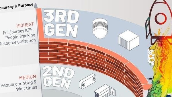
The 4 Typical Functionalities of LiDARs on Industrial Machinery
Learn about he four main uses of LiDARs on industrial machinery and how they can improve safety, efficiency, and productivity.

In order to progress to Industry 4.0, it's important to ensure that industrial sites machinery is up to date and capable of meeting the new safety requirements.
Human operators must daily face fatigue and risk injury as they operate heavy equipments. LiDAR sensors and software help standardize these operations, making them up to 50% more efficient and cutting labor costs by up to 60%.
This article will talk about the four main uses of LiDARs on industrial machinery and how they can improve safety, efficiency, and productivity.
But first, it's important to know what LiDAR technology is before diving into its industrial applications.
Understanding how LiDAR works
LiDARs are sensors that use laser beams to measure the distance to objects and generate accurate 3D models of the environment. The scanning technology utilizes a laser that emits light waves. By measuring the time it takes for the light to hit an object and bounce back to the scanner, LiDARs can calculate the distances instantaneously based on the speed of light.
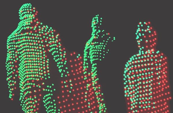
They can fire up to a thousand pulses per second, with each measurement processed into a 3D visualization called a "point cloud."
These point clouds give you pinpoint-accurate real-time data about how people, machines, and products move around in production environments and how their dimensions look like. It's like having a power to see and map out someone's large surroundings in incredible detail and in real-time. Read more in our past article:

Now let's explore the four typical functionalities of LiDARs on industrial machinery.
- Collision avoidance
LiDAR technology has contributed to industrial safety by detecting obstacles and gauging distances between objects. These sensors are strategically placed on the front and corners of machines, such as AGVs and autonomous robots, in order to ensure their precise navigation and to avert any collision, creating a safer and more efficient workplace. Read the following article to go further on this topic:

One of Outsight’s clients, Cybernetix, a European company that makes robotics solutions that improve the reliability and performance of assets around the world, has chosen our LiDAR software to give its offshore navigation robot accurate and reliable location information. The robot's software then uses this data to navigate autonomously in previously mapped environments.
LiDAR solutions offer distinct advantages over camera ones in that they are capable of functioning reliably in challenging outdoor conditions, such as rain, fog, dust, and low light. By utilizing a combination of both camera and LiDAR sensors, a clear and comprehensive picture of the environment can be obtained, regardless of the prevailing weather conditions in which the machines are operating.
2. Navigation
LiDARs (Light Detection and Ranging) are becoming increasingly crucial when associated with SLAM (Simultaneous Localization and Mapping) navigation, like the one available in Outsight software, especially in environments where GPS signal reception is weak.
These 3D sensors can detect the environment in three dimensions, and their structural reference is clear, allowing them to localize the robot or vehicle's position in relation to its surroundings. As a result, it allows robots and vehicles to safely navigate even the most complex environments.
One of Outsight’s clients, an European company that makes drones, robots, and other projects for the civil security and defense industries, chose Outsight's LiDAR Software to provide the processed 3D images and data that would help operators navigate robots and their arms more precisely.

In this security solution, the goal of the robot is to neutralize a suspicious parcel or package. The robot is controlled by an operator with a wireless connection to a remote control with a display.
Before deciding on this solution, the client also considered using a LiDAR with high resolution (and no pre-processing software) to visualize only the point cloud directly. However, this solution didn’t provide the expected resolution, distances, or position of the robot and its arm on a reference map.
3. Object identification
The utilization of LiDAR point cloud technology has engendered a revolutionary transformation in the way machines interact with their environment. LiDAR technology enables the creation of exceptionally precise 3D point-cloud maps, which, in conjunction with advanced object detection and tracking algorithms, can generate invaluable insights into the movement of both people and objects.
With Outsight’s software, objects are detected and tracked based on the 3D information captured by the LiDAR sensors, including volume, dimensions, and speed.
This is extremely useful for tasks requiring the robot to identify objects, like picking, where the robot needs to be able to recognize the object at hand to complete the task.
A forklift equipped with AGV, relocalized in a 3D map using SLAM algorithm, can detect objects
In logistics, autonomous delivery robots are using this technology to detect obstacles and navigate around them, whereas automated welding machines are using this technology to identify objects and complete welding jobs. The list only tends to grow.
4. Topology
LiDAR solutions are changing the way we measure and map natural resources. For example, by using sensors to capture the topology of windrows, grains, mineral fields, etc., we can obtain precise and accurate volume measurements.
This information can be leveraged to optimize harvest procedures or monitor the health of crops and minerals.
On a different example, with LiDAR solutions, farmers can quickly detect potential obstacles and problems, such as soil erosion or subsidence, and take proactive steps before any long-term damage happens. This technology also lets us keep track of how the land changes over time so managers can update their plans.

Lastly, it's worth noting that LiDAR solutions can help track water consumption and identify areas of water stress, allowing for more efficient use of resources.
The Path Ahead
The automation wave will inevitably transform the way we operate industrial machinery. But just like human beings need our senses to respond to our environment intelligently, machines need sensors and software to do the same.
By combining the four typical applications of LiDAR solutions – collision avoidance, navigation, object identification, and topology – machines can autonomously move around the environment and complete tasks without human input. It helps reduce costs, minimize errors, and increase safety and productivity.
Download our newest whitepaper or talk with a Product Specialist to get your LiDAR solution ready.