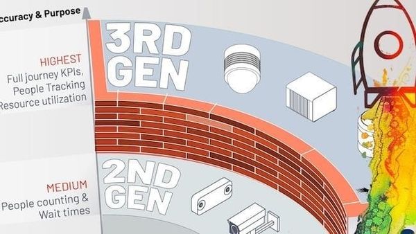
The TOP 5 applications of LiDAR solutions
From smart cars and robots to logistics, construction, and agriculture, multiple businesses are impacted today by LiDAR's flexible and highly precise solutions

Let's start with a brief introduction: LiDAR technology is an optical technology that uses infrared light to measure distances, localize an object, or create an area map. It is one of the most valuable and versatile technologies of our time.
The potential applications of this technology are vast and varied, ranging from intelligent vehicles and automated machines to supply chain management, building and infrastructure, woodland management, and farming. In this guide, we'll deep-dive into the top five most relevant applications of LiDAR technology.
ADAS
When most people think of the top applications of LiDAR, they think of autonomous cars. However, LiDAR technology has a broader role in the automotive industry, especially with ADAS or advanced driver assistance systems. These systems avoid collisions and create safer situations for road users. Unlike traditional safety measures like seat belts (passive), ADAS are active safety solutions.
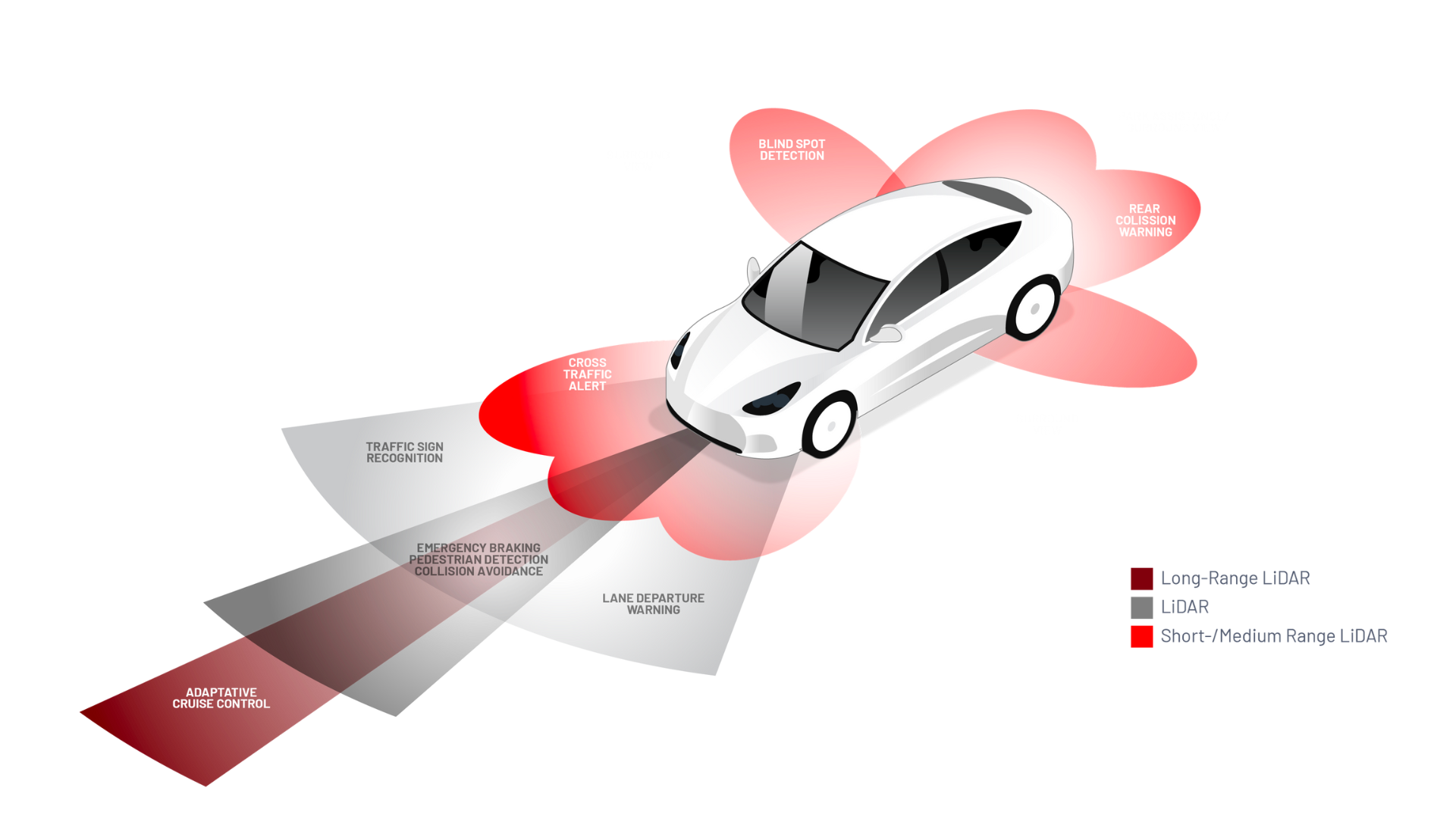
LiDAR technology for ADAS includes lane departure warnings, blind spot detection, and adaptive cruise control.
Modern automotive features can be integrated into vehicles during production or added as aftermarket options.
According to Canalys research1, more and more automobiles nowadays have built-in ADAS capabilities: the percentage of cars using ADAS features will go from 10% in 2020 to 30% in 2030 and 50% in 2050. These safety measures are required to get the desired results on new vehicle assessment ratings such as EuroNCAP.
Use Case: Commercial Vehicles Safety
Many commercial vehicles, such as trucks, are incorporating LiDAR hardware.
For reference, the global autonomous truck market was valued at USD 846.2 million in 2019 and continues to grow at a CAGR of 12.8% through 2027, according to Polaris Market Research2.
As one of the most dangerous industries, trucking can massively benefit from LiDAR technology, improving driver safety and reducing the risk of accidents at construction sites and mines.
Indeed, LiDAR sensors can play a decisive role in anticipating dangerous situations. They can provide essential data to detect obstacles or reveal the presence of pedestrians or bicyclists. In these cases, the vehicle can activate the appropriate emergency systems, such as automatic braking or lane-keeping assistance.
Autonomous Truck at the Port of Dubai
Use Case: Self-Driving Cars
It is becoming more evident that LiDAR sensors will be necessary for Level 4 (High Driving Automation) and Level 5 (Full Driving Automation) autonomous vehicles. For example, the car manufacturer Mercedes has already planned to integrate them into its top-of-the-range models to assist autonomous driving in its production vehicles.
LiDAR technology is important for self-driving cars because it helps ensure that vehicles follow the correct route and pose no unnecessary risks to passengers or other road users, even in unknown environments.
For example, Outsight supported the creation of a fully autonomous shuttle that navigated through a university campus using its LiDAR software. The shuttle can detect moving objects and adjust its route to avoid them.
An Autonomous Shuttle Navigating Through a Campus
Use Case: Generating Reference Data
LiDAR sensors generate helpful reference data to benchmark the performance of other sensor technologies, such as radars and cameras, on moving vehicles.
Therefore, with the data, there are possibilities to make other technologies even more efficient when providing safe road conditions for users.
By creating Ground Truth data with Outsight software, it is possible to have a reliable source of tracked objects, both dynamic and static (landmarks).
Objects and Landmark Tracking & Classification
Smart Infrastructure
Smart Cities and related topics such as Intelligent Transportation Systems (ITS) are becoming increasingly popular worldwide, with LiDAR technology playing a key role in their growth and development.
The precision of LiDAR's 3D data, its operation in various settings, including direct sunlight and at night, and its ability to ensure privacy makes it ideal for deploying smart infrastructure solutions.
The worldwide smart city market is expected to reach US$2.86 trillion in 2026, growing at a CAGR of 20% between 2022 and 20263. This growth is fueled by increased global urbanization and rising technology spending on smart city efforts.
There's lots of scope for this technology to be used further in Smart Cities, and there are already plenty of examples of LiDAR applications for smart infrastructure, including:
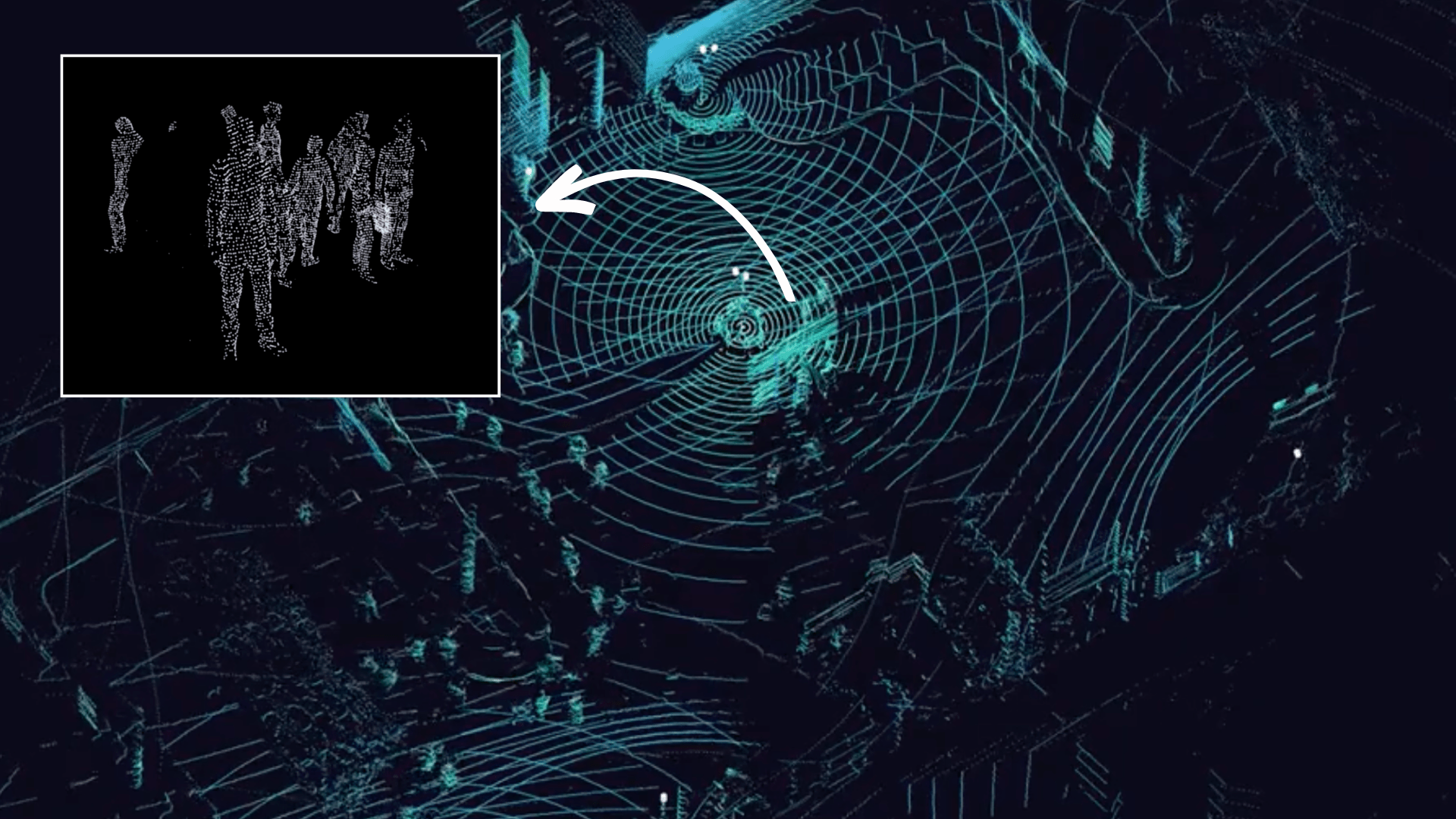
Use Case: Intelligent Transportation Systems (ITS)
One of LiDAR's main applications is ITS. In this case, Outsight's Augmented LiDAR software and LiDAR sensors can detect and track vehicles, pedestrians, and other objects in a large surveillance area.
LiDAR systems can be fine-tuned for applications such as crosswalk safety, overspeed alerts, pedestrian near-misses, and more, contributing significantly to developing smarter, safer urban environments.

The output is an actionable Dashboard with real-time alarms triggered by specific events or aggregated data over long periods.
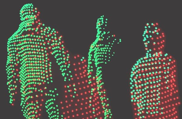
Use Case: Anonymous People Tracking
In many ways, airports are like small, enclosed cities, complete with paths, walkways, flows of people, parking, retail zones, and more.
By combining Edge AI and cloud-based technology, the Augmented LiDAR software enhances spatio-temporal visual analysis of large spaces like train stations, malls, airports, and more. The software allows for precise detection, tracking, and understanding of crowds of people anonymously.
Unlike Camera Face ID, LiDAR data allows for the detection and tracking of persons and objects. However, the resolution of even the best-performing sensors does not allow for recognition, rendering this technology completely anonymous.
Airport Terminal - Showcasing the live 3D Viewer
Additionally, LiDAR solutions can effectively track and prevent lost luggage, which is likely to cause significant delays.
These functions also apply to train stations, subways, and other modes of public transportation.
Use Case: Spatial Intelligence and Security
Another one of the top applications of LiDAR is for Spatial Business Intelligence.
LiDAR can track and generate actionable metrics about various actions and situations throughout an airport environment, including customs and passenger flows through security and other key areas, luggage belt optimization, seat occupancy, and more.
It can also be used for security purposes, instantly generating alerts about unexpected events if some metric reaches a threshold or an intrusion happens within a security zone or perimeter.
Complete LiDAR solution, from simulation to dashboard, with Outsight software and PTZ Integration within Milestone VMS
Robotics
Another one of the top five applications of LiDAR is robotics.
This industry is growing more extensively and more significantly with every passing year, and the rate of development shows no signs of slowing down, with a global growth rate of 15.3%, according to Renub Research4.
For those wondering, LiDAR technology is at the core of the smart vehicle and robotics revolutions.
The main application of LiDAR to robots is to make them safer to work with and around. Due to their autonomous nature, these machines require the highest standards of safety technology, and LiDAR can reduce the risks of accidents or injuries.
Use Case: Path Following for Deliveries
Imagine you have an automated guided vehicle, or AGV, inside a warehouse. The car must navigate safely and accurately to the warehouse's specific pick-up and delivery locations.
A LiDAR-enabled path following Outsight's relocalization technology can allow the robot to understand how it's moving and where it is in a reference map—for example, a warehouse map.
Relocalisation of Automatic Guided Vehicle (AGV) using Outsight's SLAM on Chip
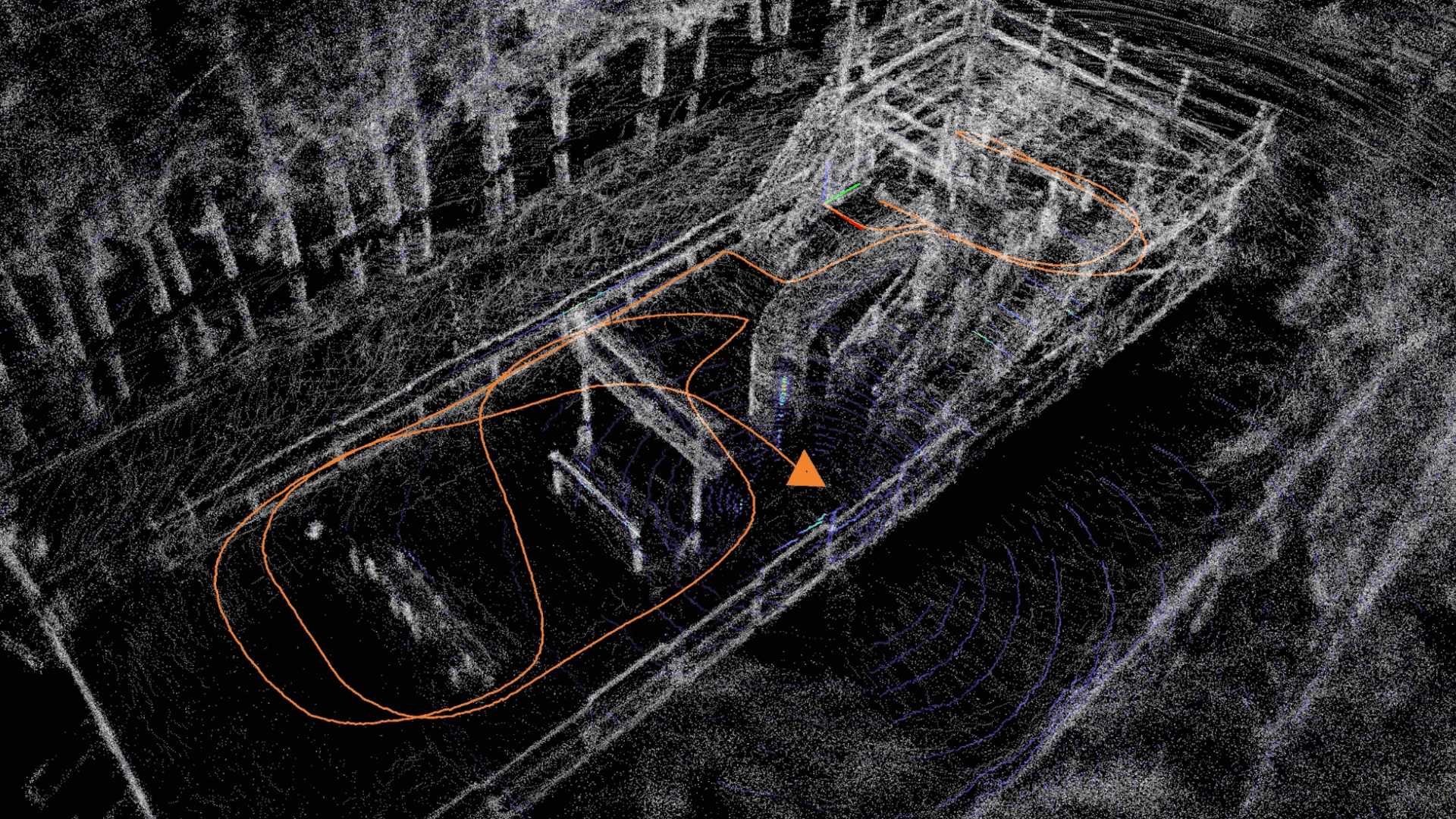
Use Case: Security Robots
One of the main ways robotics and LiDAR can work together is in security robots. These robots move around areas of interest, like the perimeter of a building, following a set trajectory. An operator may wish to re-localize the robot's route after an event, where the LiDAR comes into play.
Autonomous Robot Working in a Warehouse
Use Case: Fleets
LiDAR can also be helpful in situations involving multiple smart robots or vehicles operating as part of a unit or fleet and sharing the same space. The cars or robots must know their positions and orientations to operate safely together. Once more, LiDAR technology can assist in this scenario.
Industrial
Arguably, one of the most widespread top applications of LiDAR technology is industrial safety; LiDAR hardware and software can improve safety in industrial workspaces and raise business productivity and efficiency with the aid of real-time 3D insights.
With its reliable data and adaptability, LiDAR technology in industrial markets makes many situations and places safer for workers.
According to a report by Insight Partners, the industrial automation market could reach 238 billion dollars in 2028, with an average annual growth rate of over 7%5.
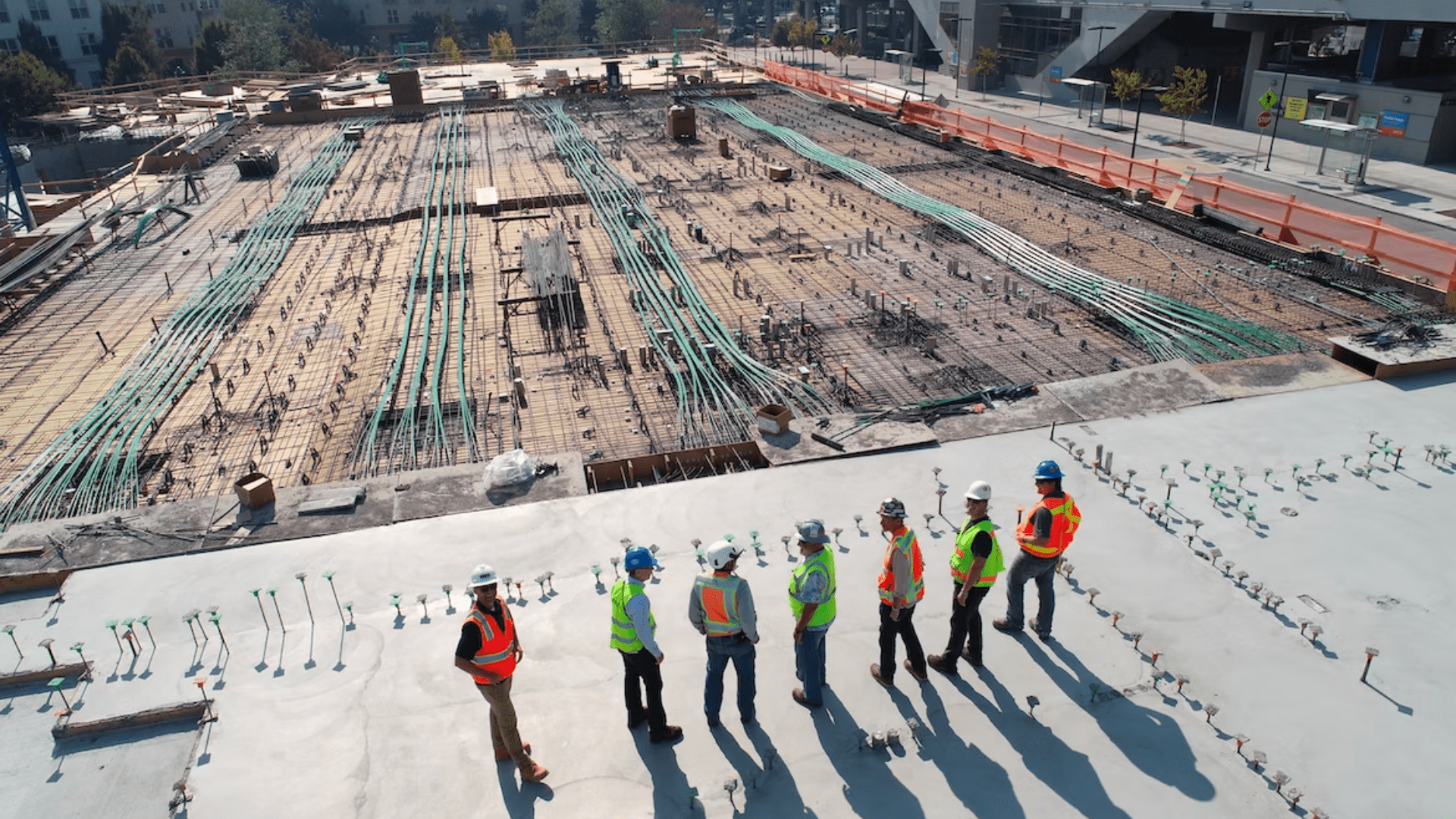
Use Case: Construction Site Safety
Construction sites can be some of the most dangerous places. LiDAR is an excellent application that helps improve safety standards in and around these areas. LiDAR software tracks distances between human workers, large machines, and vehicles, and alerts can be issued if dangerous situations arise.

Use Case: Teleoperation of Heavy Equipment
One of the most interesting growing trends in terms of applications and uses of LiDAR is providing pathways for third-person teleoperation of heavy equipment and machinery in industries like mining and construction.
When equipped with the right software, LiDAR provides the unique capability for remote operation from a third-person point of view in real time. This advantage offers high accuracy levels and reduces accident rates when working with heavy machines.
Use Case: Volume Measurement
Another industrial application of LiDAR is determining the volume of objects, like trucks, as they pass through a gantry.
In this example, augmented LiDAR software can allow users to leverage LiDAR technology to autonomously detect each vehicle's load volume, saving huge amounts of time and simplifying a formerly complex process.
Mapping
Finally, the last of the top five applications of LiDAR is mapping.
LiDAR mapping is probably the oldest application of LiDAR. However, it is still a rapidly growing field of technology, and it's possible to look at thousands of potential and current use cases when it comes to using LiDAR for mapping in industries like forestry, agriculture, city planning, and much more.
LiDAR mapping involves using laser scanning systems and advanced SLAM algorithms to precisely measure and map out space with accurate geo-referencing, forming a precise 3D representation of the target area.
LiDAR maps are unique in that they provide absolute positional accuracy, and it's possible to map entire cities in this way. Here are some example use cases:
Use Case: High-Density 3D Mapping
Thanks to the high-grade technology of modern ALB devices, it's possible to make high-density 3D maps quickly.
Entire cities or sections of land can be mapped in 3D with stunning precision, and anyone from city planners to forestry companies can use these maps. For reference, one of Outsight clients used our software's mapping feature to localize all street lamps from a certain region on a map.
Mapping application: Extraction of Street Lamps from a Map
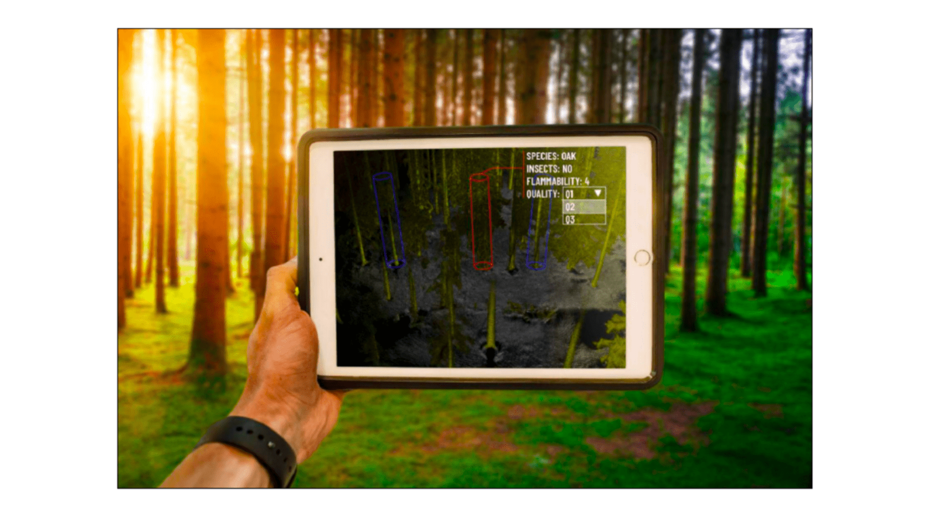
Use Case: Forestry Management
Following on from the previous point, the forestry industry can significantly benefit from the applications of LiDAR technology.
LiDAR can make 3D maps of forests, essential for forest management and development over time. Thanks to Outsight's software, a ground operator can easily create a forest map.
Forest mapping by a ground operator
Use Case: Trains
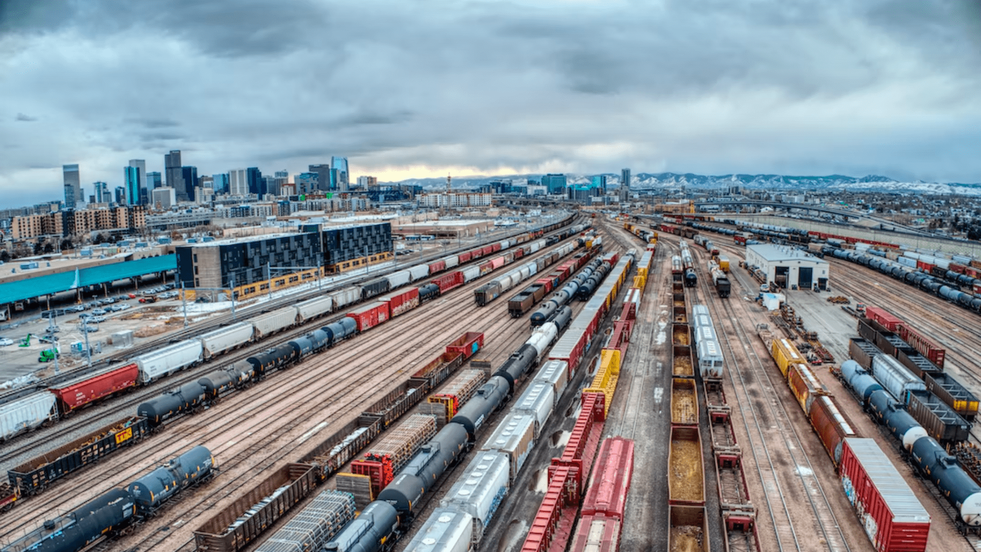
Another use of LiDAR mapping is for railways. Long-range and medium-range LiDAR detection devices can be used to map out the spaces around railway tracks, and vegetation monitoring along rail routes can be carried out. The application of LiDAR in this industry makes trains safer, smarter, and more efficient.
LiDAR: Technology with Endless Application Potential
Thanks to LiDAR software, now LiDAR can be applied to almost endless use cases.
This technology has no limits, from making industrial environments safer to helping with forest management and paving the way for the future of safe, autonomous cars.
LiDAR can improve and optimize almost anything that moves or requires movement monitoring or measurement.
At Outsight, we're using real-time software to push the limits of LiDAR even further.
Contact a product specialist today to learn more or download our most recent whitepaper about one of the applications overseen in this article:

Sources
- canalys.com, “Huge opportunity as only 10% of the 1 billion cars in use have ADAS features”, Sep 2021
- polarismarketresearch.com, “Autonomous Truck Market Share, Size, Trends, Industry Analysis Report By Level of Autonomy (Level 1, Level 2, Level 3, Level 4, Level 5); By Sensor Type (Radar, LiDAR, Camera, Ultrasonic); By End-Use (Logistics, Construction & Manufacturing, Mining, Port); By Region - Segment Forecast, 2020 - 2027”, Aug 2020
- ResearchAndMarkets.com, “Global Smart City Market (By Application & Region): Insights & Forecast with Potential Impact of COVID-19 (2022-2026)”, May 2022
- globalnewswire.com, “Global Robotics Market is projected to grow to US$ 86.20 Billion by 2027”, Nov 2022
- theinsightpartners.com, “Industrial Automation Market Forecast to 2028 - COVID-19 Impact and Global Analysis By Component (Hardware and Software), System Type (Supervisory Control and Data Acquisition, Distributed Control System, Programmable Logic Control, and Others), and End Users (Oil & Gas, Automotive, Food & Beverage, Chemical & Materials, Aerospace & Defense, and Others)”, Mar 2022