Digitizing Movement: The next generation of Digital Twins
Integrating people flow monitoring into Digital Twins with LiDAR and Spatial Intelligence delivers real-time insights, optimizing safety and efficiency.

Introduction
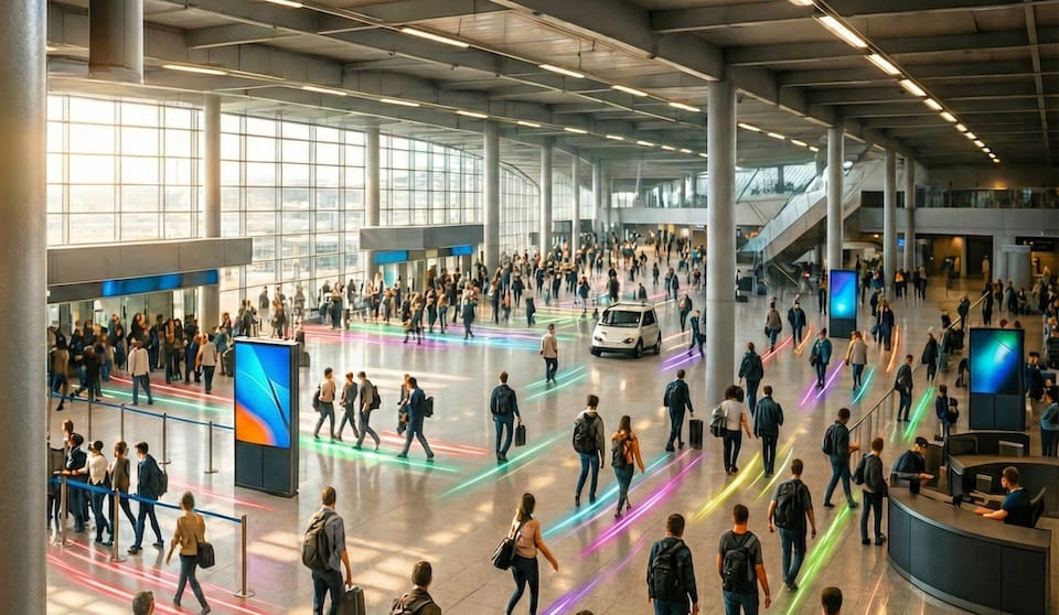
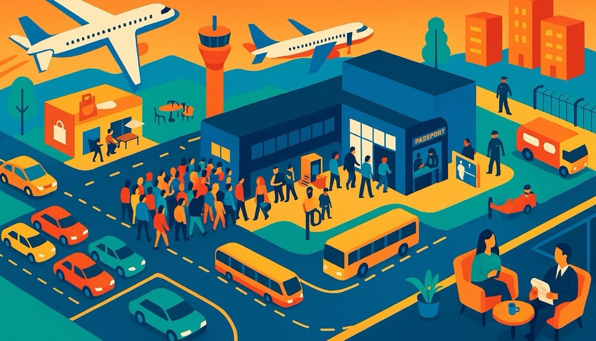
Complex infrastructure environments—from airports to industrial facilities—face a persistent challenge: the lack of real-time, actionable data about how people and vehicles move through physical spaces.
Motional Digital Twins (MDTs), powered by Spatial Intelligence and 3D native sensors like LiDAR, are transforming this landscape by providing continuous, precise visibility into dynamic flows.
This article explores how integrating people flow monitoring into Digital Twins addresses critical operational problems, improves efficiency, and supports privacy—all while leveraging the unique strengths of LiDAR and Spatial Intelligence.
Bridging Data Gaps: Achieving Visibility into Physical Flows
Traditional infrastructure management often suffers from a fundamental blind spot: operators cannot see or quantify the real-time movement of people and vehicles. This data gap leads to inefficiencies, unresolved customer pain points, and unaddressed safety risks.
MDTs solve this by acting as real-time digital replicas that continuously track and analyze movement throughout a facility. By transforming invisible flows into actionable insights, MDTs empower operators with the Spatial Intelligence needed to make informed decisions.
LiDAR, when combined with Spatial AI, enables continuous individual tracking across entire premises with centimeter-level precision. The result is a structured, contextualized understanding of movement, not just aggregate counts.
Optimizing Capacity and Managing Complexity
As infrastructure usage grows, organizations must maximize the capacity of existing facilities without the luxury of immediate expansion. Airports, for example, often operate near or at full capacity, making efficient flow management essential.

MDTs provide the Spatial Intelligence foundation for optimizing operations within current constraints. By delivering real-time and predictive insights—such as actual and forecasted wait times or resource utilization—operators can make timely adjustments to staffing and facility usage.
These insights are not generic; they are specific, actionable, and tailored to the dynamic realities of each environment. For instance, knowing the precise occupancy of a waiting area or the actual queue length at security enables targeted interventions.
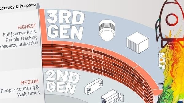
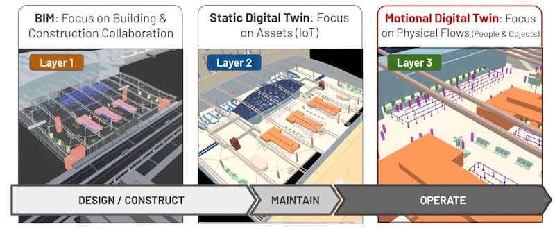
Overcoming the Limits of Legacy Technologies
Legacy Digital Twins and static data sources, such as Building Information Modelling (BIM), focus primarily on assets rather than dynamic flows. Camera-based systems, meanwhile, struggle with lighting changes and cannot deliver continuous, high-precision tracking across large areas.
MDTs overcome these limitations by digitizing movement as a core capability. Real-time awareness is built into both data acquisition and processing, allowing for immediate operational impact.
LiDAR stands out as the most advanced and capable technology for this purpose. It perceives in 3D over long distances, emits its own light, and operates reliably in complete darkness or variable lighting. This ensures uninterrupted, premises-wide tracking that is both accurate and robust.

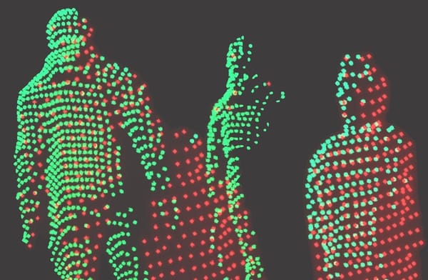
Ensuring Privacy in People Flow Monitoring
Public resistance to image-based and wireless surveillance is growing, driven by legitimate privacy concerns. MDTs address this by enabling anonymous tracking that respects individual privacy.

LiDAR offers a key advantage: it does not capture any personally identifiable information.
People are represented only as symbols within the system, and no images are recorded or displayed. This native privacy preservation is reinforced by the MDT platform, which ensures that all tracking remains completely anonymous.
Real-World Applications: Solving Operational Challenges
MDTs are not limited to a single industry or use case.
Their precise, continuous tracking and situational awareness capabilities address a range of operational problems across different sectors. Here are several examples:
Organizations benefit from these capabilities in diverse ways:
- Transportation Hubs: MDTs accurately count people and vehicles, measure dwell times, monitor queues, and provide real-time alerts for overstays, spacing, and speed. This enhances both efficiency and safety at curbside areas.
- Railway Platforms: Continuous monitoring of passenger trajectories helps anticipate risky behaviors in crowded situations, enabling proactive incident prevention.
- Retail and Tourism: MDTs support accurate staff scheduling by adapting workforce deployment to actual demand, using precise flow and interaction data.
- Smart Cities & Roads: By focusing on vulnerable road user (VRU) safety, MDTs provide the accurate perception needed for accident reduction initiatives like Vision Zero.
- Industrial & Logistics: Anonymous monitoring of workers and industrial vehicles enhances workforce safety and delivers comprehensive situational awareness, reducing false positives.
Conclusion: The Future of Digital Twins with Spatial Intelligence
Integrating people flow monitoring into Digital Twins represents a significant advancement for infrastructure operators seeking to address the challenges of visibility, capacity, and privacy.
MDTs, powered by LiDAR and Spatial Intelligence, provide the actionable insights needed to optimize operations, enhance safety, and respect privacy across a wide range of environments.
As leaders in this field, we at Outsight are committed to delivering robust, privacy-preserving solutions that help organizations achieve measurable improvements in efficiency and safety. Our technology is trusted by operators worldwide to provide the real-time, 3D spatial awareness that modern infrastructure demands.